© All rights reserved. The Borough of Etna
Flood Information
To learn more about your risk, what to do to protect your property, before, during, and after a flood, and how to purchase flood insurance, you can call the National Flood Insurance Program at 1-
Etna Borough Flood Services:
Flood maps and flood protection references are available at the municipal building in the flood library section. There is no charge for the photocopying of this info. Reference material is also available at the Shaler North Hill Library on Mt. Royal Blvd. -
Allegheny County Hazard Mitigation Plan
How Flooding Can Occur In Etna Borough - Flood Warning System
Flooding in Etna can be caused by three direct sources: West Little Pine Creek, Pine Creek and the Allegheny River. There are several “storm runs” in the Borough that can cause flooding in specific areas: the Park Avenue Storm Run; the Parker Street Storm Runs and the Ganster Street Storm Run.
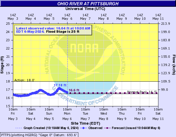
When the Allegheny River crests beyond 26 feet, flooding occurs in the low lying areas of Sycamore and Cherry Streets but at higher crest levels can include Railroad/Middle Streets and the lower portion of Bridge Street (near Sycamore Street).
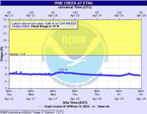
The United States Geological Service (USGS) has a stream gauge located in Pine Creek at the Crescent Avenue Bridge near Dewey Street. The Emergency Management Committee of the Borough has this gauge link on their cell phones so that it can be monitored from anywhere by that Committee. This committee consists of the Emergency Management Coordinator (EMC), the Assistant EMC, the Mayor, Police and Fire Chiefs, and the Borough Manager. When this gauge hits thirteen feet, flooding is a high probability and over thirteen feet, flooding can be eminent. Benchmarks have been preset, which activate the Borough’s Flood Warning system, based on these gauges (which are not in exact real time – may be off by an hour) and predicted forecasts. The gauges are listed here: Two for Pine Creek in Etna – one is the National Weather Service Advanced Hydrologic Prediction Service and the USGS and one for the Allegheny River at the Point – USGS. You can monitor the levels of these two waterways here. We have shared the bench marks in which the Borough begins to take action with our Flood Warning System which follows, but you can monitor these gauges yourself and when the waters are rising but not at these benchmark levels and continued rain is predicted, you may choose to take steps in anticipation of possible flooding, such as moving items from your basement, plugging sewers, sand bagging or leaving the area until the threat has passed.
Flooding can occur through several routes in our community, either by overflowing of the creek or river banks, the overflowing of storm water runoff culverts or by sewer system overload and backup. Dumping and littering adds to potential problems. Because we are a combined sewer community (sanitary and storm water are combined in the same piping system), littering on the street can be washed into the storm catch basins during a rain event. This can clog up the sewer system and take up vital space for the storm and sanitary flow. PLEASE DO NOT LITTER.
What You Can Do:
-
Maintenance of the drainage systems is critical in helping prevent or minimize the severity of flooding. The "runs" that are discussed in the "flood protection information" sheet are inspected quarterly and after every rainfall by the Public Works Department. This includes removing any debris, i.e., fallen trees, rocks, and other trash. Even the buildup of dirt and mud needs to be removed on a regular basis. It is crucial that residents do not add to the natural buildup by throwing any debris into these runs, over hillsides, and creek banks. This includes trees in a precarious situation (in jeopardy of falling). Anyone caught doing such, will be cited and fined.
- Do not dump or throw anything into the ditches, streams or "runs". Doing so is in violation of borough ordinance No. 1215. This includes grass clippings and branches, etc. This ordinance carries stiff fines and penalties for violation.
-
If your property is next to a ditch, stream or "run", please do your part and keep the banks clear of debris.
-
If you see someone dumping, contact the Borough Office immediately at (412) 781-
0569, or during off business hours the Etna Police Department at (412) 473- 3056. -
Always check with the Building Dept. before you build on, alter, re-
grade, or put fill on your property. A permit may be needed to ensure that projects do not cause problems to other properties. -
If you see building or filling without a borough permit posted, contact the Building Dept. at (412) 781-
0569. -
Check out the following information on flood proofing, flood insurance and flood safety.
Floodplain Maps

Flood Safety
- Do not walk through flowing water. Drowning is the number one cause of flood deaths. Six inches of moving water can knock a person off of their feet. If you walk in standing water, use a pole or stick to make sure the ground is still there.
- Do not drive through a flooded area. Do not drive around barricades or barriers because the road or bridge may be washed out beyond them.
- Stay away from power lines and electrical wires. Electrocution is the second leading cause of death during flooding. Report down power lines to Duquesne Light immediately or to the Police Department.
- Look out for small animals, especially snakes. Use a stick or pole to poke through the water and turn things over where small animals may hide, to scare them away.
- Look before you step Floors, stairs, and even the ground can be very slippery with mud after flooding. Debris, including broken glass or nails may also cover the ground surface.
- Be alert for gas leaks. Do not smoke or light open flames unless you know the gas has been turned off and the area properly ventilated. Contact Equitable Gas or Peoples Gas to report leaks or the Police Dept.


